The Tuscobia Trail is a 74-mile state trail in northern Wisconsin and we have the full guide with maps, hikes and activities available.
Offering a multitude of recreational opportunities throughout the year, it stretches from Park Falls in the east to the Wild Rivers State Trail just north of Rice Lake in the west.
This trail is unique as it is one of the longest rail-trails in the state, situated on a former rail corridor.
Designed for multiple uses, the Tuscobia State Trail welcomes activities such as ATVs, snowmobiling, horseback riding, off-road bicycling, and walking.
Its versatility makes it a year-round destination for outdoor enthusiasts, with trail activities varying by time of year and by county. Notably, the western end of the trail is also part of the Ice Age National Scenic Trail.
The trail’s route includes travel through the Flambeau State Forest and Chequamegon National Forest, showcasing the rugged wilderness of the Blue Hills. The nearly-level former rail grade allows for an enjoyable experience across its lengthy stretch.
Along the way, trail users can visit quaint shops in small villages, adding a cultural aspect to the outdoor adventure.
The trail also provides opportunities to enjoy the natural beauty and serenity of northern Wisconsin, making it a popular choice for both residents and visitors looking for an outdoor adventure.
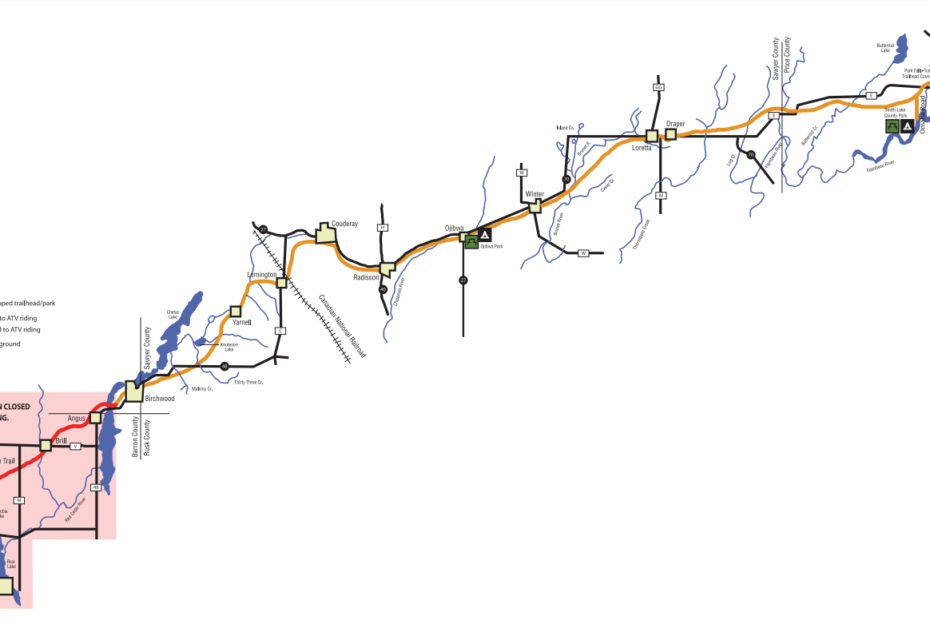
Tuscobia Trail Maps
Use this map as a guide to plan your vacation along the Tuscobia State Trail. Many of the communities offer lodging and restaurants, as well as other amenities.
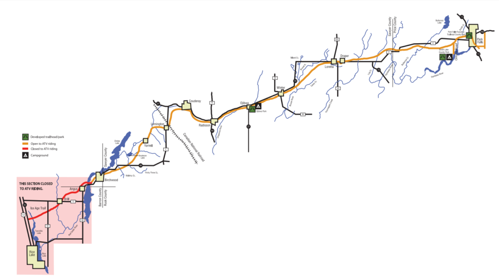
You can also download a PDF here.
Tuscobia Trail Activities
There are a full range of activities to enjoy on the Tuscobia Trail with details below:
ATVing
ATVing is permitted from Park Falls to just west of Birchwood April 15-November 15 and provides a good
opportunity to view the wildlife and historical sites along the trail.
The map highlights the specific ATV trail. ATV riders are required to stay on the trail.
Hiking / Horseback Riding
Hiking and Horseback riding are fantastic ways to see all that Tuscobia State Trail has to offer.
There is plenty of natural beauty and historic sites, as well as restaurants and retailers along the trail to make a complete vacation.
The terrain on the trail does vary, so proceed with caution. It is a good idea to use the contact information to learn more about the portions of the trail you plan to hike or ride.
Canoeing, Kayaking, Fishing
With several waterways located near or along the Tuscobia State Trail, there are plenty of opportunities for canoeing and fishing.
The Birchwood area offers especially good trout fishing. The Chippewa River, near the Ojibwa stretch of the Tuscobia is very popular for canoeing and fishing.
The Brunet River, located east of Winter offers trout, as well as musky fishing. The numerous low rapids are attractive to many kayakers.
Near the Park Falls area, three creek crossings provide fishing and scenic outlook options. The creeks flow into the Flambeau River, a popular canoeing and kayaking destination.
Snowmobiling
Snowmobiling is allowed on the entire length of the Tuscobia State Trail, snow conditions permitting.
The terrain on the trail does vary, so proceed with caution and ride safely.
The Tuscobia State Trails
Rice Lake
The western terminus is at Rice Lake, Wisconsin, in Barron County. From the western end to Angus,
this stretch of the trail is part of the 1,000-mile Ice Age National Scenic Trail.
Rice Lake provides users with a variety of amenities including trail parking, lodging, restaurant, retail and service establishments.
For more information, contact the Rice Lake Tourism Commission at 1-800-523-6318.
Birchwood
From Rice Lake to Birchwood, you’ll travel through open farmland, numerous pothole lakes and creeks with various recreational activities, such as hiking, fishing (particularly trout fishing), and nature studies, as well as several interesting historical sites.
Birchwood offers gas, food, lodging, sporting goods and ATM service. For more information contact the Dairy State Bank 1-715-354-3411.
Couderay/Radisson
On this stretch of the Tuscobia, discover the beauty of the Blue Hills: eroded roots of ancient mountains that might have been as high as the Rockies! The Couderay River is also near the trail.
Learn more about the history of the railroad and the logging industry at the historical sites when you visit Radisson, which also offers gas and food options.
For more information contact the Winter Area Chamber of Commerce at 1-800-762-7179.
Ojibwa
Take advantage of the scenic Chippewa River Valley, where this portion of the trail veers from being open to forested and has large populations of deer, grouse and songbirds; watch for bald eagles!
The Chippewa River is very popular for canoeing and fishing. Ojibwa Park is located at the halfway point directly across the highway from the Chippewa River with facilities including camping, electric, pit toilets, hand pump, shelter, picnic tables and fire pits.
Ojibwa also has gas and food options. For more information contact the Winter Area Chamber of Commerce at 1-800-762-7179.
Winter
The Brunet River is located along the Tuscobia Trail east of Winter and offers excellent trout and musky fishing and numerous low rapids.
Large old pine stumps suggest the size and frequency of the area’s original timbers.
Visit the original railroad station in downtown Winter. Winter offers repair service, gas, food, lodging, and retail.
For more information, contact the Winter Area Chamber of Commerce at 1-800-762-7179.
Loretta/Draper
From Winter to Loretta/Draper you enter what was once the heart of the logging industry along the
Tuscobia Trail.
History will be a constant presence, as you will notice the old railroad ties under the sod of the trail.
The Loretta/Draper area offers gas, and food. The Chequamegon National Forest is just north of the Tuscobia and offers camping.
For more information, contact the Winter Area Chamber of Commerce at 1-800-762-7179.
Park Falls
At the eastern end of the trail is Park Falls. You’ll find terrain perfect for ATVing and snowmobiling with options for gas, lodging, camping, restaurant, retail and service establishments.
The Park Falls-Tuscobia Trailhead County Park offers ample parking, an ATV loading ramp and seasonal flush toilets.
Smith Lake County Park & Campground, just west of Park Falls, has direct access to the trail.
For information contact the Park Falls Area Chamber of Commerce at 1-800-762-2709 or the Price
County Tourism Department at 1-800-269-4505.
Safety Message
The Tuscobia State Trail is a state treasure and should be enjoyed by outdoor enthusiasts of all interests. Please make safety a priority while using the Tuscobia State Trail.
- Follow all regulations by requesting specific trail information for each area as rules can vary.
- Be certain your equipment is in good mechanical condition at all times.
- Wear sensible protective clothing.
- Use proper safety equipment at all times.
- Make efforts to know the terrain by asking others who have traveled on it before or by calling one of the
contacts for more information. - If you choose to use the trail at night, make certain you have proper operating lighting systems.
- Stay on the trail.